Index: Syrian-American Businesses 1908
Introduction
In 1908 Salloum Mokarzel (the brother of Naoum Mokarzel, the publisher of Al-Huda, one of the earliest Arabic newspapers in the US) and H.F. Otash published an Arabic/English directory of the businesses owned by “Syrians” (as all early immigrants from the Eastern Mediterranean were called) in the US.

What does the Directory contain?
- Catalog of the businesses
- Serve as a link between the traders and manufacturers and their American counterparts
- Proclaim the “Syrians” as “born businessmen” who fit naturally into the American capitalist system
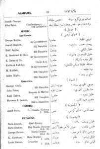
A century later, the directory provides an intimate look into early business owners. With over 3,300 businesses, the Directory represents a significant sample (around 25%) of early immigrants in 1908, and thus can be taken as closely resembling the overall Lebanese-American population. The directory (to the right) lists in English: state, city and street address of the business, the name(s) of the owner(s), and the type of business they run. In Arabic, the directory provides the names, type of business and their natal village, town or city in the Middle East.
What do the maps show?
We have used the Directory to create 2 maps. The map contains the location, provenance and types of businesses that these early immigrants owned.
The first map shows where business owners came from in the Middle East. The second map shows their distribution in the US. In both instances the map may be filtered in two ways.
- Profession
- Place of Origin (with Lebanon divided into five areas for ease of display)
How can I use the map?
When the map first displays (there’s a lot of data to load, so please be patient), the default is “Dry Goods” stores and “All” for place of origin. This means that the map is showing you everyone who listed their business as “Dry Goods” within the directory regardless of their provenance.
You can choose a sub-category for place, like “Mount Lebanon,” and the map will show you only those who came from that area and who worked in Dry Goods, which sold clothing, textiles, non-perishable goods like coffee, etc .
For each selection, you will notice that the box on the right will display the total number of business owners who fit that criteria. If you zoom in and hover over one of the dots, the name of the village or town will be displayed, along with the number of business owners from that place, and their location and numbers in the US.
The map below displays the distribution of early Lebanese-American businesses in the US. You can filter this map in very similar way to the one above. Moreover, this map provides us the best approximation for the distribution of the early immigrants population in the US. Not surprisingly, the Northeast (and particularly New York City) had the greatest concentration of immigrants. However, what quickly becomes obvious is that the South (including Texas) houses signifcant populations as well and this is indeed a new perspective that only becomes visible with this map.
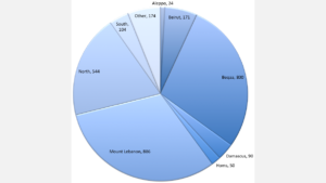
In addition to the dynamic maps above, we have also added a couple of pie graphs to provide a “bird’s eye” view of the distribution of professions, as well the areas from whence the immigrants hailed.

